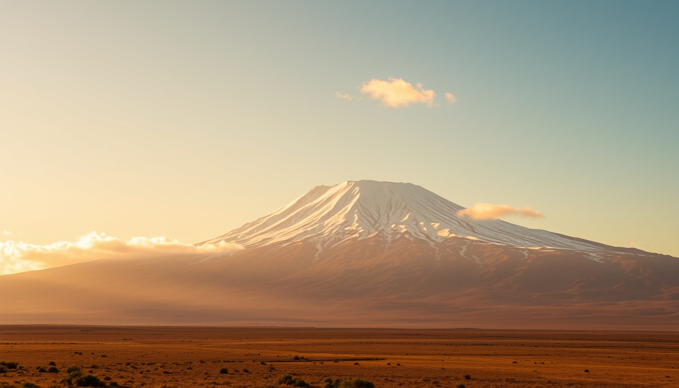
Mount Kilimanjaro, a dormant stratovolcano in northeastern Tanzania, carries the title of the highest mountain in Africa. Its summit, Uhuru Peak, sits on the crater rim of the Kibo cone and draws thousands of trekkers each year. The mountain’s status as the world’s highest free-standing peak adds to its appeal, but the climb presents real physical challenges.
Kilimanjaro is not just one mountain but a complex of three distinct volcanic cones. Shira, the oldest, collapsed long ago, leaving a plateau. Mawenzi and Kibo are younger, with Kibo remaining the tallest. This geography defines the climbing experience, where altitude and weather, not technical climbing skill, are the main obstacles.
What is the exact height of Kilimanjaro in feet and metres?
The generally accepted elevation for Uhuru Peak, the apex of Kilimanjaro, is 5,895 meters (19,341 feet) above sea level. This figure is widely cited by Tanzanian authorities, UNESCO, and leading geographical references. It represents the standard measurement despite slight differences in older surveys.
5,895 m (19,341 ft)
Tanzania, East Africa
Uhuru Peak (Kibo cone)
Moderate to strenuous (non-technical hike, altitude main challenge)
While 5,895 m is the standard, some modern surveys have recorded slightly different elevations. Figures of 5,892 m, 5,899 m, and 5,902 m appear in various records, likely due to improved measurement methods and minor changes in snow and rock structure. Despite these, the 5,895 m figure remains the consensus.
Measuring a mountain’s height is not as straightforward as it might seem. Kilimanjaro’s summit elevation is particularly challenging to pin down because it lacks a long-term, permanent weather station at its peak. The height is derived from satellite data and ground-based GPS surveys, each with its own precision levels. Erosion and the lack of a solid bedrock summit also contribute to small variations.
- Free-standing mountain: Kilimanjaro rises about 4,900 m from its plateau base, making it the highest free-standing mountain above sea level in the world.
- Volcanic cone: The summit area is on the Kibo cone, one of three volcanic cones that form the mountain.
- First climb: Hans Meyer and Ludwig Purtscheller made the first successful summit in 1889, alongside Yohani Kinyala Lauwo.
- Not technical: The climb is a high-altitude trek, not a rock-climbing ascent, but success depends on acclimatization.
- Glaciers shrinking: Kibo’s glaciers are retreating and may disappear entirely by 2050.
- Seven routes: There are seven established climbing routes, each with different stress and success rates.
What is Uhuru Peak?
Uhuru Peak, the name means “Freedom” in Swahili, is the highest point on Kilimanjaro. It is located on the crater rim of the Kibo cone. This specific spot is the finish line for all trekkers, and it marks the true top of Africa. Getting to Uhuru Peak is the entire goal of a Kilimanjaro climb.
Reaching Uhuru Peak is the culmination of a multi-day journey. The trek to the summit usually starts in the midnight hours to ensure climbers reach the top by dawn, avoiding the most intense heat of the day. The final ascent to Uhuru is a steady, exhausting scramble up a steep slope, under the light of a headlamp.
| Fact | Value |
|---|---|
| Height (metres) | 5,895 m |
| Height (feet) | 19,341 ft |
| First ascent | October 6, 1889 (Hans Meyer, Ludwig Purtscheur, Yohani Kinyala Lauwo) |
| Country | Tanzania |
| Mountain type | Stratovolcano (dormant) |
| Number of routes | 7 established climbing routes |
| Base camp elevations | Marangu Gate: 1,870 m (6,135 ft); Londorossi Gate: 2,100 m (6,890 ft) |
| Summit temperature | −7°C to −20°C (20°F to −4°F) at night |
Where is Mount Kilimanjaro located?
Kilimanjaro lies in northeastern Tanzania, near the border with Kenya. The mountain is situated within Kilimanjaro National Park, a UNESCO World Heritage site. The park also covers the montane forest, moorland, and alpine desert environments around the summit. This location places the mountain roughly 300 miles south of the equator, creating a unique environment where the heat of the savannah meets the icy summit.
The mountain’s geography is defined by three volcanic cones. The summit itself is on the crater of the Kibo cone, which is the youngest and highest. The Shira cone is the oldest and is now a plateau, while Mawenzi is a jagged third peak. These geological features shape the sites and trails that climbers experience.
Is Kilimanjaro a free-standing mountain?
Yes, Kilimanjaro is noted for being the world’s highest free-standing mountain. Unlike most major peaks, it is not part of a mountain range. It rises approximately 4,900 m (16,100 ft) from its plateau base, creating a dramatic vertical stature. This unique verticality is what earns it the title of highest free-standing mountain above sea level.
The mountain’s base is a plateau in the East African Rift system, at an elevation of around 800–900 m. The immense vertical difference between this base and the summit makes the climbing experience one of constant, sustained upward effort.
For a Kilimanjaro climb, the length of the route matters less than the time spent at altitude. Longer routes provide slightly more space for acclimatization and often yield a better summit success rate. Each climbing route has a different acclimatization profile, so the choice of route influences the body’s adaptation to altitude.
How difficult is it to climb Kilimanjaro?
Climbing Kilimanjaro is a high-altitude trek rather than a technical rock climb. The absence of any technical obstacles means that the physical challenge is largely one of endurance and altitude management. The Marangu route is the shortest, while the longer Lemosho route is often recommended for better acclimatization. However, the summit reward remains the same once you reach Uhuru Peak, so the effort varies considerably depending on the chosen path.
How many deaths occur on Kilimanjaro peak?
There is no official, publicly updated annual count of deaths on Kilimanjaro. Estimates from operators and anecdotal data put the number between 10 and 30 fatalities per year, out of over 35,000 climbers. This would represent a fatality rate of roughly 0.1–0.3%. The primary cause is altitude sickness, which can lead to High Altitude Pulmonary Edema (HAPE) or High Altitude Cerebral Edema (HACE).
The biggest risk on Kilimanjaro is not the physical terrain but the air. Altitude sickness is the most serious threat, and it can affect anyone, regardless of age or fitness. It’s important to treat any headache or nausea as a sign to slow down and rest.
Deaths are not often publicized, but they are not uncommon. A very few incidents occur due to slips on loose scree near the summit, but most are attributed to the effects of altitude sickness. The key risk factor is how fast the ascent is. Longer climbs, with additional acclimatization days, have a significantly higher chance of success.
What is the best route for a Kilimanjaro peak hike?
Several routes lead to the summit, varying in length, difficulty, and scenery. The Marangu route is the oldest and most popular, nicknamed the “Coca-Cola route” due to its hut accommodations. It is considered the easiest in terms of terrain but has a lower success rate because of the itinerary averages, though it’s a good choice for those with a higher fitness level.
On the other hand, the Lemosho route is considered the best for acclimatization. It starts on the western side of the mountain and takes longer, allowing trekkers to adapt properly. There’s evidence that it has a high summit success rate, as it provides a good balance of altitude gain and rest. Other routes like Machame and Northern Circuit are also well regarded.
Route selection significantly affects acclimatization and success more than raw distance. For first-timers, a route that allows for a proper “climb high, sleep low” pattern is the most efficient way to avoid altitude sickness and reach Uhuru Peak.
What is the temperature at the summit of Kilimanjaro?
At the summit, Uhuru Peak, the temperature swings dramatically between day and night. Due to the altitude, night-time temperatures of −20°C (−4°F) are possible. Daytime temperatures are much higher, but still below freezing at the top. In a gear check, the most common window for summit attempts is at night, when temperatures are at their coldest.
The mountain crosses several climate zones, so the weather also changes with altitude. Temperatures on the lower slopes are warmer, but during the midday sun, it can be hot. The key to a successful climb involves a degree of layering for all these types of weather.
While the summit is cold, the base camp weather is more comfortable. The weather is a factor of preparation. It’s more about planning for the extremes rather than a specific temperature prediction.
What is the elevation of Kilimanjaro base camp?
Base camp elevations vary by the chosen route. The traditional Marangu Gate is at 1,870 m (6,135 ft), which is the starting point for the Marangu route. The Londorossi Gate, on the other side of the trail of the Lemosho route, is slightly higher at 2,100 m (6,890 ft).
These are the points where climbers register and formally start the climb. The variation in starting altitude affects the immediate distances and the route’s initial profile. However, the overall struggle remains, as climbers will all have to tackle the same vertical terrain to reach Uhuru.
A Kilimanjaro timeline: From formation to the glacier’s retreat
Kilimanjaro is both a geological and a historical landmark. Its formation is deeply rooted in volcanic activity, and the story of its summit is one of constant change.
- ~2–3 million years ago: Volcanic activity forms the mountain, with three cones (Kibo, Masai, and Shira). Shira collapses, leaving a plateau.
- 1889: First summit attempt is successful. Hans Meyer and Ludwig Purtscheller, alongside Yohani Kinyala Lauwo, an African guide, make the historic ascent.
- 1920s: The mountain becomes a protected forest reserve. This later evolves into a national park and is later expanded.
- 1973: Kilimanjaro is officially designated a national park to protect its unique ecosystem.
- 2019: Mandatory GPS tracking is introduced for all climbers to improve safety and management.
- 2020–present: Glacial retreat accelerates; an expected prediction is that the current glaciers are to vanish by 2050.
What is certain and what remains unknown about Kilimanjaro?
There is a clear separation between what is known and what still shows uncertainty.
Well-established information
- The standard summit height is 5,895 m (19,341 ft) according to Tanzanian authorities and UNESCO.
- Location: Tanzania, East Africa.
- Uhuru Peak is the highest point on the Kibo cone.
Information that remains unclear
- Minor altitude differences exist in surveys (5,892–5,902 m) due to precision and erosion.
- Official, regularly updated death statistics are not publicly released.
- The exact glacier disappearance timeline depends on climate scenarios; forecasts range from 2030 to 2060.
Why does Kilimanjaro hold such a powerful meaning?
Kilimanjaro stands as a geographic icon, representing Africa’s heights and natural beauty. It’s a bucket-list destination for adventurers from around the globe, not just because of its height but because it’s a serious, doable challenge. It is a National Park and a UNESCO World Heritage Site, further cementing its status as a global treasure, and the impact of its shrinking glaciers is taught worldwide.
For Tanzanians, the mountain is more than the highest point in Africa; it’s a permanent natural marker. For travelers, a successful summit brings a unique mix of struggle and triumph. The practical details of the climb, like base camp altitude, difficulty, and route choice, are what separate those who succeed from those who have to come down early. The perception of risk is further shaped by safety data, making general knowledge about the mountain crucial.
Where can I find reliable sources and quotes about Kilimanjaro?
Accurate information comes from a handful of authoritative sources. Primary references include Encyclopedia Britannica and Wikipedia for baseline measurements. For climatic detail, data is often sourced from long-term research, although no official weather station exists permanently at the peak.
“Kilimanjaro’s central landmark, the Kibo cone, rises to 19,340 feet (5,895 meters) and is the highest point in Africa.”
— Britannica
“Mount Kilimanjaro is the highest mountain in Africa and the highest free-standing mountain above sea level in the world, at 5,895 m (19,341 ft) above sea level.”
— Wikipedia
For practical, climbing-oriented advice, operators like Climbing Kilimanjaro offer a more realistic perspective on summit rates and guide-based approaches; they report a 98.8% summit rate and are certified guides. For a personal perspective, Ian Taylor Trekking notes that most people benefit from 8 to 9 days, which balances safety and acclimatization.
For planning, the official Tanzania National Parks authority provides regulatory updates and fee schedules. If you are more interested in the geology, you might want to check the data from the Global Volcanism Program, which shows that the volcano is dormant as a scientific reference. For climate data, the NOAA can connect a broader dataset.
What is the quick answer for someone planning to climb Kilimanjaro?
In summary, Kilimanjaro’s highest point is Uhuru Peak, at 5,895 m/19,341 ft. It is in Tanzania and is a trekking challenge, not a technical climb. The main difficulties are altitude and temperature, which is unique. For those seeking further guidance on high-altitude treks, follow the Base Camp Mount Everest – Complete Guide for a comparative look. Alternatively, a different kind of hill experience can be found in the Cadair Idris – Height, Routes, Legend & Visitor Guide or for more specific UK mountaineering.
Frequently Asked Questions
How many deaths occur on Kilimanjaro each year?
Estimates range from 10 to 30 deaths annually out of ~35,000 climbers (0.1–0.3%). Most are due to altitude sickness or accidents.
What is the best route for beginners?
The Lemosho route is often recommended for acclimatization and success, while the Marangu route has hut accommodation but a lower success rate.
Can I climb Kilimanjaro without a guide?
No. Rules require all climbers to be accompanied by a licensed guide for safety.
Does Kilimanjaro have snow year-round?
Yes, but glaciers are rapidly shrinking. Snowfall occurs mainly in the rainy seasons (March–May, November–December).
What is the elevation of Kilimanjaro base camp?
Base camps vary by route: Marangu Gate is 1,870 m, Londorossi Gate is 2,100 m, and Mweka Gate is 1,640 m.
What is Uhuru Peak?
Uhuru Peak is the highest point on Kilimanjaro, on the rim of the Kibo cone.
Which is higher, Kilimanjaro or Everest Base Camp?
Everest Base Camp is higher at ~5,364 m, but Uhuru Peak is a true summit.
How long does it take to climb Kilimanjaro?
A typical climbing time ranges from 5 to 9 days, with longer itineraries improving acclimatization.
Which is better? Lemosho or Machame?
Lemosho is longer and has better acclimatization, but Machame is more scenic and popular for the view.
How can I prevent altitude sickness?
The best prevention is to take slow, progressive climbs with rest days and stay well hydrated and aware of symptoms.
Base Camp Mount Everest – Complete Guide
Cadair Idris – Height, Routes, Legend & Visitor Guide

Oliver Arthur Morgan Harrison is a staff writer for StoryShift.uk, covering UK news, culture, politics and technology. He works under Editor-in-Chief Maarika Tamm and UK Managing Editor Oliver Grant, following the newsroom standards for sourcing, verification and fact-checking set out in our editorial policies.